Padma River
The Padma is the most dynamic river in Bangladesh. The length of the river is about 100km. It originated from Paturia and its outfalls with the Upper Meghna River. It is a braided river. Padma carries the combined flow of the Jamuna and the Ganges Rivers. The river planform is different than the rivers in the southwest region of Bangladesh. For example, Pasur, Shibsa, Baleswar, etc.
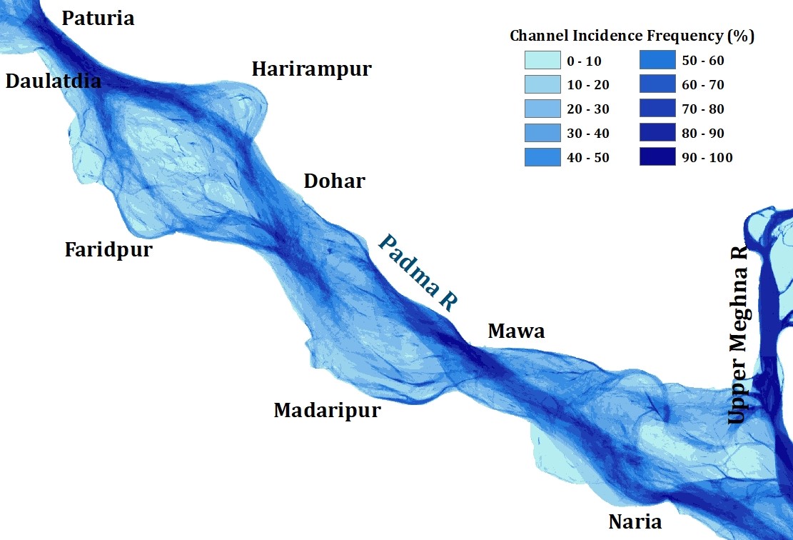
A channel incidence map is very important to assess the frequency of the channel for a particular given period. The frequency of the channel incidence map in the last 49 years from 1973 to 2022 shows that the presence of the channel was high at Paturia, Daulatdia, Mawa and Naria locations. The percentage of incidence ranges from 90 to 100 percent.
Moreover, it is very prominent that the channel incidence frequency of the Upper Meghna River is 100%. This reveals that the existence of the channel at the same position in the last five decades. While the main channel of the Padma River is not fixed at a particular direction or along the fixed bank. Rather it shifts either along the left or right bank.
River provides fresh water to the Lower Meghna River which eventually distributes it to the Meghna estuary and the Sundarbans in the south-central region of Bangladesh. This helps to reduce the salinity level of the river which is good for the aquatic life that is sensitive to the saline water.
This section mainly gives information of the Jamuna River at the immediate upstream of the Jamuna Bridge. It provides the detailings of the channel from 1973 to 2020 with an interval of an nearly five years. River Dynamics in 1973 River pattern in 1980 Dynamics of the Jamuna River Figures explains the fact that river…
Introduction The Aral Sea lies in between Kazakhstan and Uzbekistan. The northern part of the sea is located in Kazakhstan while the southern part is in Uzbekistan. It was the fourth-largest sea in the world. But, the sea is no more the real sea now. The water area was about 60 km2 in the 1970s…
The Kosi River is one of the most dynamic river in the world. It originates from Himalayas and passes by China, Nepal and India before joining with the Ganges River at Kursela, Bihar, India. The total length of the river is about 720 km. Planform Nature The planform nature of the Kosi River differs it…
Understanding of the dynamic of the confluence is very important for proper planning and management of the river. It not only change the bifurcation of the Lower Meghna River at the downstream but also it altered the shifting of the banklines along its both banks. This section provides the dynamic of the Lower Meghna River…
Agro-ecology of the Barind Tract Barind Tract is one of the important agro-ecological zones in Bangladesh. It is located in the NW part. The largest physiographic unit of the Bengal Basin is considered as most drought-prone area. The zone can be categorized as High, Level and North-eastern Barind Tract. Agro-ecological zone of Barind Tract Main…
Bend Development Process Meanders are the result of erosion-deposition processes tending toward the most stable form in which the variability of certain essential properties is minimized and this minimization involves the adjustment of the planimetric geometry and the hydraulic factors of depth, velocity, and local slope. Bend development process is very active in the major…